

What if a satellite orbiting hundreds of kilometers above the Earth could help local governments make better environmental decisions? Today, this is no longer a distant possibility. Advances in satellite technology, combined with scientific research and field observations, are transforming how cities monitor air pollution. More importantly, they demonstrate that solving environmental challenges is no longer the responsibility of a single institution it requires collaboration among scientists, governments, technology providers, and communities.
Makassar, one of Indonesia’s fastest-growing metropolitan cities, illustrates why this collaborative approach is becoming increasingly important. Rapid urbanization, expanding transportation networks, industrial activities, and population growth have significantly increased the concentration of airborne particulate matter (PM₁₀), one of the pollutants that poses serious environmental and public health concerns. However, obtaining accurate information about air quality across an entire city remains challenging because conventional monitoring stations are limited in number, expensive to establish, and unable to provide comprehensive spatial coverage.
This study investigates the spatial distribution of PM₁₀ concentrations in Makassar City, Indonesia, using Landsat 8 satellite imagery combined with ground-based measurements. PM₁₀ concentrations were measured at 30 observation points and modeled using Landsat 8 spectral Bands 1–4 through Multiple Linear Regression. The model was developed using 80% of the dataset and independently validated using the remaining 20%. Results demonstrated a good relationship between satellite-derived spectral information and ground-measured PM₁₀, confirming the potential of Landsat 8 for spatial air pollution assessment. The resulting PM₁₀ maps can help identify pollution-prone areas and support air quality monitoring and urban environmental management in cities with limited monitoring stations.
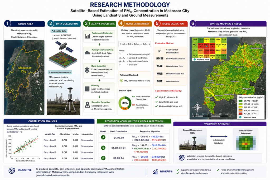
To address this challenge, researchers developed an innovative monitoring approach by integrating Landsat 8 satellite imagery, ground-based PM₁₀ measurements, and multiple linear regression analysis. Rather than relying solely on field observations, the study combined satellite spectral information with direct measurements collected from 30 monitoring locations distributed throughout Makassar. This integrated approach enabled researchers to estimate and map PM₁₀ concentrations across the city while validating the satellite results using actual environmental data.
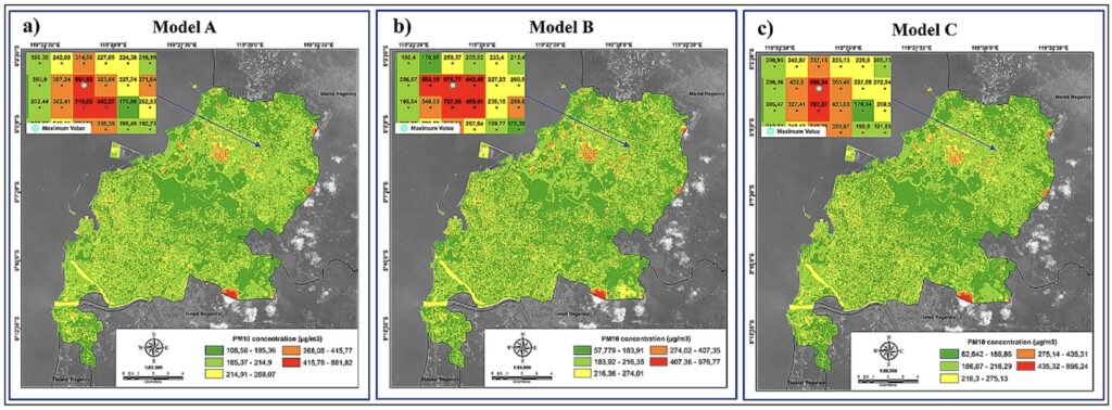
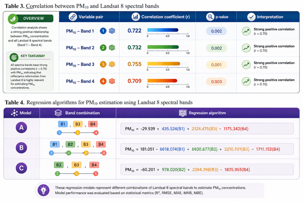
The findings demonstrate that combining multiple Landsat 8 spectral bands provides reliable estimates of PM₁₀ distribution. Among the tested models, the integration of Bands 1-4 produced the strongest predictive performance, indicating that satellite imagery can effectively identify areas with higher particulate concentrations. Although satellite estimates should not replace direct field monitoring, they significantly improve the ability to visualize pollution patterns across large urban areas where monitoring infrastructure remains limited.
Beyond its technical achievements, this study highlights a broader transformation in environmental management. Air pollution can no longer be addressed through isolated monitoring activities. Instead, it requires an integrated system where satellite technology supplies extensive spatial information, researchers develop predictive models, field technicians validate environmental conditions, and policymakers translate scientific findings into effective regulations. Such collaboration enables environmental decisions to be based on evidence rather than assumptions, allowing resources to be directed toward locations facing the greatest pollution risks.
The research also demonstrates how remote sensing technology can become an affordable solution for developing countries with limited environmental monitoring infrastructure. Satellite observations provide consistent and repeatable information over wide geographical areas, while field measurements ensure that the resulting models remain scientifically reliable. Together, these complementary methods create a stronger environmental monitoring system capable of supporting sustainable urban planning and long-term pollution management.
This research directly contributes to Sustainable Development Goal (SDG) 17: Partnerships for the Goals, which emphasizes strengthening cooperation among governments, academic institutions, technology providers, and other stakeholders to achieve sustainable development. The successful integration of satellite remote sensing, field validation, and statistical modeling demonstrates how interdisciplinary collaboration can generate innovative, cost-effective solutions for complex environmental problems. By encouraging knowledge sharing, technological innovation, and evidence-based policymaking, this study provides an excellent example of how partnerships can accelerate environmental sustainability while improving the quality of decision-making for future urban development.
As environmental challenges become increasingly complex, no single technology or institution can solve them alone. The future of sustainable cities depends on strong partnerships that combine scientific expertise, technological innovation, and public commitment. In that future, satellites do far more than observe our planet they connect knowledge with action, helping societies make smarter decisions for a cleaner and more sustainable world.