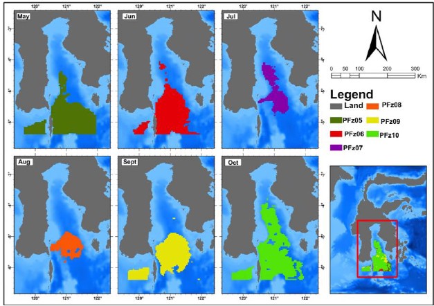
Satellite-based maps reveal how potential fishing zones for scad fish (Decapterus ruselli) shift across Bone Gulf from May to October 2024.
MAKASSAR, Indonesia Aug 29 2026/TRG/ – A fishing ground may look empty from the surface, but satellites can reveal where the ocean is creating favorable conditions below. In Bone Gulf, South Sulawesi, researchers have used remote sensing to map potential fishing zones for scad fish (Decapterus ruselli), a small pelagic species that supports coastal livelihoods and contributes to Indonesia’s fisheries economy.
The study combined MODIS-AQUA satellite data on sea surface temperature and chlorophyll-a with actual catch locations. These two oceanographic indicators help describe the environmental conditions that influence where scad fish are likely to gather. Sea surface temperature affects fish metabolism and movement, while chlorophyll-a provides an indication of marine productivity and the availability of food at the base of the food web.
Finding the Ocean Conditions Fish Prefer
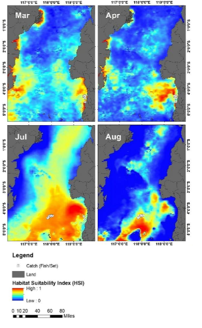
Researchers identified a preferred environmental range of about 28.3–30.7°C for sea surface temperature and 0.05–0.21 mg m⁻³ for chlorophyll-a. Catch locations were strongly associated with relatively cooler waters and areas of higher chlorophyll-a, suggesting that productive waters can create attractive feeding and aggregation zones for scad fish.
Fishing Hotspots Do Not Stay in One Place
The satellite analysis revealed that these potential fishing zones were far from static. Between May and October 2024, their size and location changed substantially with seasonal oceanographic conditions. In May, suitable zones were concentrated in western and central coastal waters before extending toward the middle of Bone Gulf in June. They narrowed and shifted in July and August, expanded again toward the central and southeastern areas in September, and became most extensive in October.
October recorded the largest estimated potential fishing zone at approximately 24,478.51 km². By comparison, August had the smallest, at about 6,819.07 km². This more than threefold difference shows how strongly fishing opportunities can change within only a few months.
Checking Satellite Predictions with Real Catches
Importantly, the researchers compared the predicted zones with actual catch locations from September and October. Many catch points, including locations with catches above 800 kg, fell within the areas predicted by the satellite-based approach. This spatial agreement strengthens the potential use of remote sensing as a practical tool for fisheries planning.
For fishers, knowing where favorable conditions are developing could reduce unnecessary searching, fuel use, and operational costs. For fisheries managers, the same information can support more adaptive decisions, including when certain areas should be prioritized or approached conservatively.
The study contributes most directly to SDG 14: Life Below Water by supporting science-based and ecosystem-based fisheries management. It is also relevant to SDG 1: No Poverty through more efficient small-scale fishing, SDG 4: Quality Education through the application of satellite science, and SDG 17: Partnerships for the Goals through collaborative research.
In Bone Gulf, satellites are doing more than observing the ocean. They are helping turn changing water conditions into information that can guide where, when, and how fishing is carried out more efficiently and sustainably.
DOI:
https://doi.org/10.21608/ejabf.2025.434405
Mukti Zainuddin
Corresponding Author
Department of Fisheries, Hasanuddin University
Phone: +62 852-5591-3244
Email: mukti@unhas.ac.id