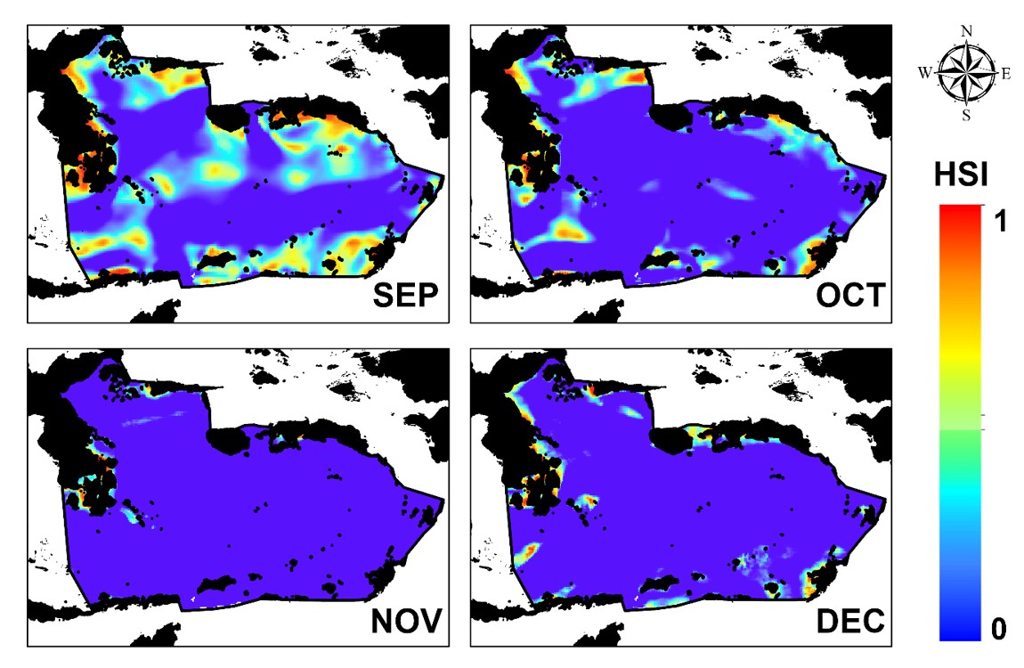

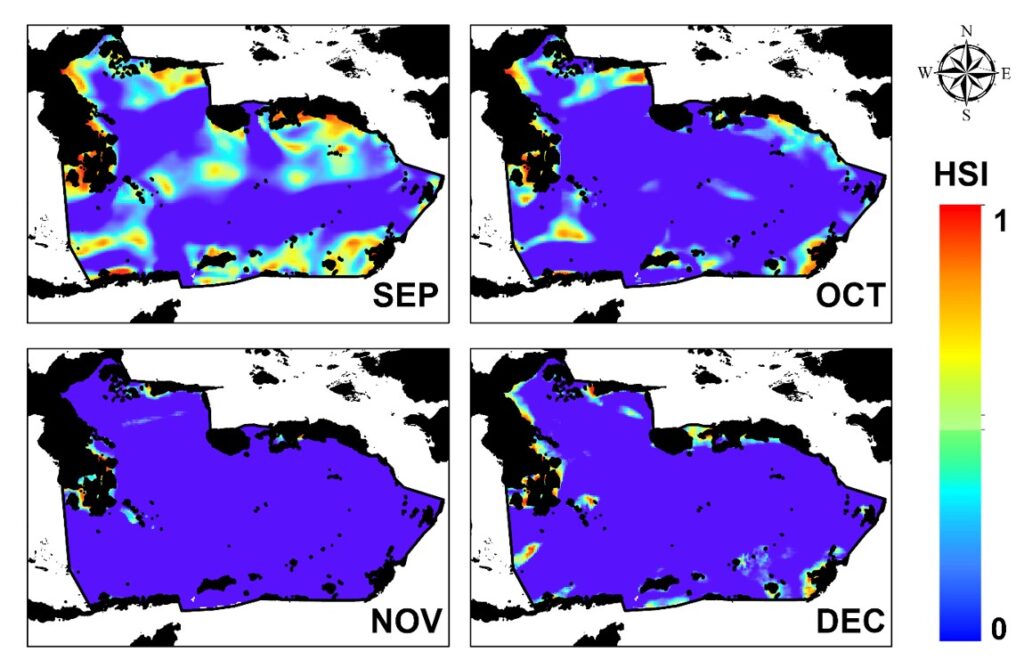
Satellite-based habitat maps reveal how suitable areas for Indian anchovy (Stolephorus indicus) shift across the Banda Sea from September to December.
MAKASSAR, Indonesia Aug 29 2026/TRG/ – A small fish can have a very large role in the ocean. Anchovy (Stolephorus indicus) is not only an important catch for coastal fisheries, but also a key food source for larger predators such as tuna and skipjack. In the Banda Sea, however, these fish do not remain in the same place throughout the year. Their preferred habitat moves as ocean conditions change.
Researchers from Hasanuddin University and Universiti Kebangsaan Malaysia examined this seasonal movement by combining anchovy fishing records from 2020–2022 with satellite-derived oceanographic data. The study used the Maximum Entropy, or MaxEnt, model to predict where suitable anchovy habitats are likely to occur based on sea surface temperature, chlorophyll-a, salinity, sea surface height, and ocean current velocity.
When Is the Best Time to Find Anchovy?
The Fishing Seasonal Index showed a clear annual pattern. November emerged as the peak fishing month, with the index exceeding 150%, while June represented a low fishing period with values below 50%. For habitat modeling, the researchers focused on September through December, when fishing activity showed a sustained seasonal increase.
The maps revealed that anchovy habitat is highly dynamic. In September and October, highly suitable areas were more widely distributed along the western and southern parts of the Banda Sea. By November, these areas became more concentrated, even as catch rates reached their highest level. In December, suitable habitat expanded again, particularly toward the southeastern waters. This seasonal movement suggests that anchovies continuously respond to changing environmental conditions rather than occupying a fixed fishing ground.
Currents and Food Shape the Hotspots
Among the environmental variables, ocean current velocity was the strongest overall driver, contributing an average of about 64.7% to the model. Currents were especially important in September and October, likely because they help transport plankton and influence where anchovy schools aggregate. In November, chlorophyll-a became much more influential, contributing 44%, indicating that productive waters rich in phytoplankton were closely associated with the peak anchovy season.
The MaxEnt model performed very well, with AUC values above 0.95 for every modeled month. November produced the highest value, 0.999, showing an exceptionally strong ability to distinguish suitable habitat.
From Maps to Ecosystem-Based Fisheries
These maps can help fishers reduce the time and fuel spent searching for productive fishing grounds. More importantly, understanding anchovy habitat also helps protect the wider food web because anchovies are natural prey for commercially valuable tuna and skipjack.
The study therefore supports SDG 14: Life Below Water through ecosystem-based fisheries management, SDG 1: No Poverty by improving the efficiency of small-scale fisheries, SDG 4: Quality Education through the application of scientific and geospatial knowledge, and SDG 17: Partnerships for the Goals through research collaboration and science-based management.
In the Banda Sea, knowing where anchovies move is not only about finding fish. It is about understanding how the ocean connects small pelagic species, predators, fisheries, and coastal livelihoods.
DOI:
https://doi.org/10.21608/ejabf.2025.444222
Mukti Zainuddin
Corresponding Author
Department of Fisheries, Hasanuddin University
Phone: +62 852-5591-3244
Email: mukti@unhas.ac.id