Artificial Neural Network-based prediction reveals potential Indian mackerel (Rastrelliger spp.) fishing hotspots during the November peak season in the western Banda Sea.
MAKASSAR, Indonesia Aug 29 2026/TRG/ – Finding fish at sea has traditionally depended on experience, weather, and knowledge passed between generations of fishers. But what if a computer could also learn the ocean’s signals and help predict where productive fishing grounds are likely to form? In the western Banda Sea, researchers are testing that possibility with artificial intelligence.
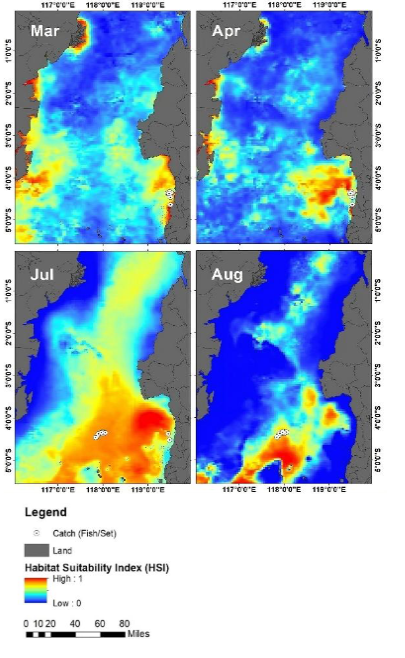
A study by researchers from Hasanuddin University and Universiti Kebangsaan Malaysia combined fisheries records, satellite observations, the Fishing Season Index (FSI), and an Artificial Neural Network (ANN) to identify the peak fishing season and predict potential habitats for Indian mackerel (Rastrelliger spp.). The research analyzed catches and oceanographic conditions including sea surface temperature, chlorophyll-a, salinity, and ocean currents.
When the Sea Signals the Right Season
The analysis identified November as the peak fishing month. The study links this period with relatively stable salinity, seasonal rainfall, winds, and changes in ocean currents that may support local upwelling. Upwelling brings deeper, nutrient-rich water toward the surface, helping stimulate marine productivity and creating favorable conditions for fish and their food.
Among the environmental variables examined, salinity and ocean currents had the strongest reported contributions to mackerel catches, at 16% and 14%, respectively. During conditions associated with high predicted catches, salinity was around 34.2 psu and current velocity around 3.29 cm per second. These findings show that a productive fishing ground is not defined by a single variable, but by the combination of physical and biological conditions in the sea.
Teaching a Neural Network to Read the Ocean
The researchers trained an ANN, a machine-learning model inspired by interconnected neural networks, to learn complex relationships between environmental conditions and fisheries data. Unlike simple linear approaches, the model can capture patterns that do not follow a straight-line relationship.
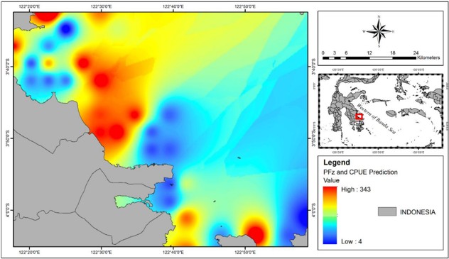
The resulting model showed an error rate of only 1.12% according to the study. It was then used to map potential fishing zones during the November peak season. The highest predicted CPUE reached 343 kg per trip under conditions that included a sea surface temperature of 31.4°C, chlorophyll-a concentrations of 0.18–1.5 mg m⁻³, salinity of 34.2 psu, and current velocity of 3.29 cm per second.
From Artificial Intelligence to Sustainable Fishing
For fishers, maps like these could eventually reduce the time, fuel, and operating costs spent searching for fish. For fisheries managers, combining seasonal information with habitat predictions could support more targeted fishing regulations, dynamic catch limits, and protection of important spawning or nursery areas.
The study directly supports SDG 14: Life Below Water through data-driven and ecosystem-based fisheries management. It is also relevant to SDG 1: No Poverty through improved fishing efficiency, SDG 4: Quality Education through the use of scientific and digital technologies, and SDG 17: Partnerships for the Goals through collaborative research.
In the future, artificial intelligence may not replace fishers’ knowledge of the sea. Instead, it could become another tool for reading a changing ocean more precisely, and fishing it more wisely.
DOI:
https://doi.org/10.21315/tlsr2025.36.3.9Mukti Zainuddin
Corresponding Author
Department of Fisheries, Hasanuddin University
Phone: +62 852-5591-3244
Email:mukti@unhas.ac.id