MAKASSAR, Indonesia Feb 6 2026/tfed/ – Have you ever imagined that the presence of fish in the ocean could be predicted by reading water temperature, color, and salinity from satellites? For little tuna (Euthynnus affinis), this information can provide important clues about where the most suitable habitats are located, while also helping fishers and fisheries managers understand how ocean conditions change from season to season.
A study conducted by Andi Risda Fitrianti Abudarda, Mukti Zainuddin, Rachmat Hidayat, and Siti Khadijah Srioktoviana from Universitas Hasanuddin explored this question through satellite-based habitat modeling. The study, entitled “Habitat modeling of little tuna (Euthynnus affinis) in Makassar Strait (Indonesia) using MaxEnt,” was published in Biodiversitas, Volume 27, Issue 1, January 2026.
Reading the Ocean to Find the Fish
The Makassar Strait is far from static. As the main pathway of the Indonesian Throughflow, the region experiences seasonal changes in temperature, productivity, and salinity. These environmental shifts help determine where pelagic fish such as E. affinis are most likely to find suitable habitat.
To understand these dynamics, the researchers combined fishing locations with three key oceanographic variables: sea surface temperature, chlorophyll-a concentration, and sea surface salinity. Temperature and chlorophyll-a data were obtained from NASA’s MODIS-Aqua satellite, while salinity data were sourced from the Copernicus Marine Environment Monitoring Service. The environmental data covered the period from January 2019 to December 2023.
The information was then incorporated into Maximum Entropy, or MaxEnt, a modeling approach that estimates habitat suitability by relating known fish occurrence locations to the environmental characteristics of the surrounding waters.
Temperature Matters, but Seasons Change the Story
The study found that sea surface temperature was the most influential environmental factor, contributing an average of approximately 57.4% to the model, followed by chlorophyll-a at 21.7% and salinity at 20.9%. However, the relative importance of these variables changed with the season. Temperature was particularly dominant in March and April, while salinity became more influential in July and chlorophyll-a made a stronger contribution in August.
E. affinis was associated with conditions of approximately 29.31°C, chlorophyll-a concentrations of around 0.22 mg m⁻³, and salinity of about 33.7 psu. The models also demonstrated good to excellent predictive performance, with AUC values ranging from approximately 0.78 to 0.92.
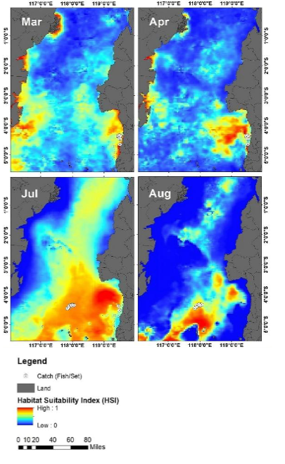
One of the most striking findings can be seen in the habitat maps. Areas of high habitat suitability were largely concentrated in the central to southern Makassar Strait, particularly around 4–5°S. In July, highly suitable habitat expanded across the southwestern part of the strait. By August, the suitable area became more spatially restricted, but distinct hotspots remained in the southern region.
From Satellite Maps to Smarter Fisheries
For fishers, habitat maps like these are more than colorful images. Information about where and when suitable habitat is likely to occur can help guide fishing operations more efficiently and reduce unnecessary time and effort spent searching for fish.
For fisheries managers, the study suggests that the southern Makassar Strait could be considered a priority area for fisheries planning and management. Monitoring systems that integrate near-real-time sea surface temperature and chlorophyll-a information may also help fishers adjust their fishing strategies as ocean conditions change.
These findings directly support SDG 14 – Life Below Water by promoting the use of ecosystem-based information in fisheries management. The study is also linked to SDG 1 – No Poverty through improved fishing efficiency and livelihood sustainability, SDG 4 – Quality Education through the advancement of marine science and technology, and SDG 17 – Partnerships for the Goals through data sharing and scientific collaboration.
Ultimately, satellites do not actually “see” the fish beneath the ocean surface. But by observing the conditions in which fish live, technology can help us understand when and where the ocean provides the most suitable home for them.
Reference
Abudarda, A.R.F., Zainuddin, M., Hidayat, R., & Srioktoviana, S.K. (2026). Habitat modeling of little tuna (Euthynnus affinis) in Makassar Strait (Indonesia) using MaxEnt. Biodiversitas, 27(1), d270142.
Contact
Andi Risda Fitrianti Abudarda
Department of Fisheries, Faculty of Marine Science and Fisheries
Universitas Hasanuddin
Email: arisdafitrianti@unhas.ac.id