

MAKASSAR, Indonesia 10 September 2026/SRI-RG/- Between 2019 and 2024, Makassar City lost 12 percentage points of its vegetation cover, while built-up land grew by the same amount, expanding from 34% to 46% of the city’s total area. Over the same five years, the city’s average land surface temperature climbed by roughly 2.1°C, and the share of land classified in the worst thermal-stress category jumped from 24% to 39%.
But what happens when a city grows so fast that the ground beneath it starts working against the very people living on it?
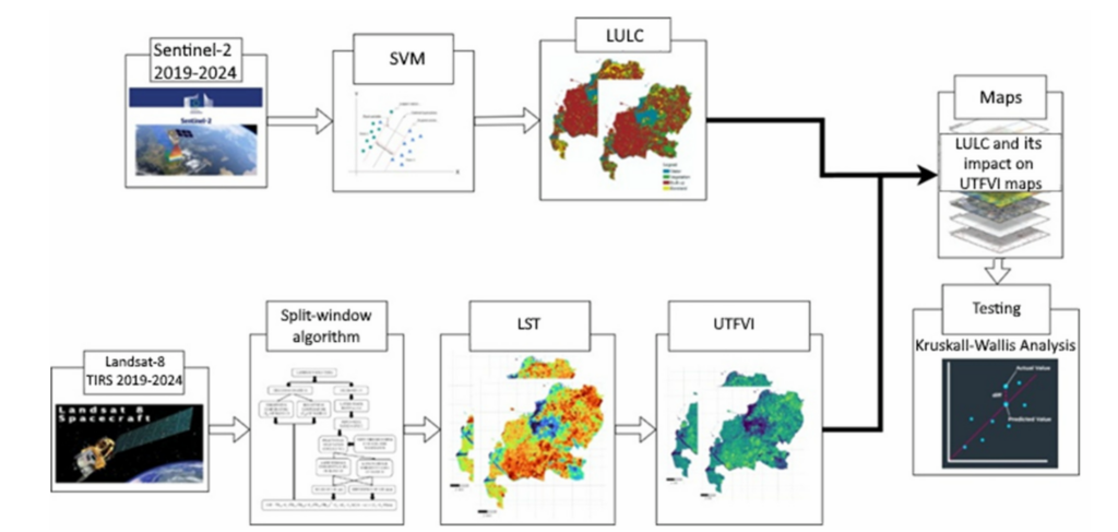
A newly published study tracked this transformation using satellite data and machine learning. The research, titled “A Machine Learning Assessment of Land Use and Land Cover Change on Urban Thermal Dynamics in Makassar,” was published in Engineering, Technology & Applied Science Research (ETASR) in August 2026. Researchers combined Sentinel-2 satellite imagery, classified using a machine learning method called Support Vector Machine (SVM), with thermal data from Landsat-8 to map how land cover and surface heat evolved across the city between 2019 and 2024.
The SVM classification proved highly reliable, correctly sorting land into water, vegetation, built-up, and bare land categories with an accuracy above 90% in both years, a level of precision that gives the researchers confidence in the trends they uncovered. What it revealed was striking: built-up land expanded not in one direction but in three distinct patterns, densifying the city center, spreading along major transportation corridors, and pushing outward toward the northern coast. Vegetation, meanwhile, shrank in almost equal measure, replaced largely by roads, rooftops, and paved surfaces.
To measure the thermal consequences, the researchers used the Urban Thermal Field Variance Index (UTFVI), which flags how much hotter or cooler a given patch of land is compared to the city average. Statistical testing confirmed that land cover type explains over 40% of the variation in surface heat across Makassar, a strong and consistent relationship in both years studied. Water bodies acted as the city’s most reliable natural coolant, consistently registering the lowest heat-stress readings, while built-up and bare land areas consistently ran hottest.
This finding connects directly to SDG 3: Good Health and Well-Being. Rising urban surface temperatures are not just an environmental statistic, they translate into real heat exposure for residents, worsening heat-related illness and cardiovascular strain, and adding discomfort, particularly for outdoor workers, children, and the elderly in dense neighborhoods with little shade or greenery.
The researchers argue the fix lies in climate-adaptive spatial planning, protecting remaining water bodies and wetlands, restoring vegetation within built-up zones rather than only at the city’s edges, and limiting the unchecked spread of impervious surfaces. As Makassar continues to grow, the study suggests that how the city plants trees, and where it chooses to pave, may matter just as much for public health as any hospital or clinic.
Reference:
DOI: https://doi.org/10.48084/etasr.16597
Contact:
Regita Faridatunisa Wijayanti (corresponding author)
Civil Engineering Department, Universitas Hasanuddin
Email: regitafw@unhas.ac.id