


Makassar, Indonesia 5 October 2025/Karstbios/ – In the middle of Jakarta’s busy urban landscape, the Angke Kapuk mangrove forest quietly performs a powerful job. It stores carbon, protects the coast, supports biodiversity, and reminds us that nature-based solutions can exist even in crowded cities. But to protect mangroves properly, managers need one important tool: accurate carbon maps.
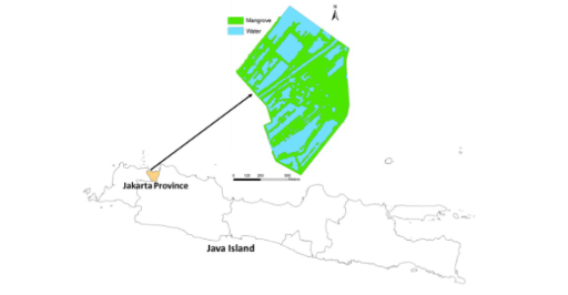
A recent study titled “Mapping Aboveground Carbon in Rehabilitated Mangrove: Evaluating the Performance of Regression Modelling with Satellite-Derived Vegetation Indices and Kriging Interpolation” was published in the Journal of Multidisciplinary Applied Natural Science by Pandawa Institute and made available online on October 5, 2025. The study examined how well two mapping approaches could estimate aboveground carbon in rehabilitated mangroves: satellite-based regression modelling and kriging interpolation.
Mangroves are often called blue carbon ecosystems because they store large amounts of carbon in their biomass and sediments. This makes them important allies in climate change mitigation. However, carbon is not spread evenly across a forest. Some areas store more, while others store less, depending on tree species, size, density, and site conditions.
In this study, researchers measured carbon in 50 field plots at Angke Kapuk, each measuring 10 × 10 meters. The results showed that aboveground carbon storage ranged from 34.76 to 236.87 tons per hectare, with an average of 135.31 tons per hectare. These numbers show that even rehabilitated mangroves can hold significant carbon value.
Satellite Data Meets Field Reality
The researchers tested vegetation indices from Landsat 8 and Sentinel-2A satellite images, including NDVI, AVI, SAVI, and forest canopy density. Surprisingly, the regression models showed weak performance, with the highest R² value only 0.03. This means satellite-derived vegetation indices explained only a very small part of the carbon variation.
Why did this happen? The rehabilitated mangrove canopy was relatively homogeneous. From above, many areas looked similar, even though field measurements showed different carbon values. This shows that satellite greenness does not always equal carbon stock.
A Better Fit with Kriging
The kriging interpolation method performed better, reaching moderate accuracy. Unlike satellite regression, kriging uses the spatial pattern of field-measured carbon data. This makes it useful for smaller and accessible mangrove areas where field surveys are possible.
Why Carbon Mapping Matters
This research directly supports SDG 14: Life Below Water, especially through the protection and sustainable management of coastal ecosystems. Healthy mangroves help protect marine life, reduce coastal risk, and store blue carbon that benefits the planet.
The message is clear: protecting mangroves requires more than planting trees. It requires good data, careful monitoring, and the right mapping method. In the fight against climate change, every mangrove tree matters—and every carbon map helps us see its value.
Article Metadata
Article title: Mapping Aboveground Carbon in Rehabilitated Mangrove: Evaluating the Performance of Regression Modelling with Satellite-Derived Vegetation Indices and Kriging Interpolation
Journal name: Journal of Multidisciplinary Applied Natural Science
Publisher: Pandawa Institute
Publication date: October 5, 2025
Reference
DOI: https://doi.org/10.47352/jmans.2774-3047.311
Contact:
Elham Sumarga
elham.sumarga@itb.ac.id


