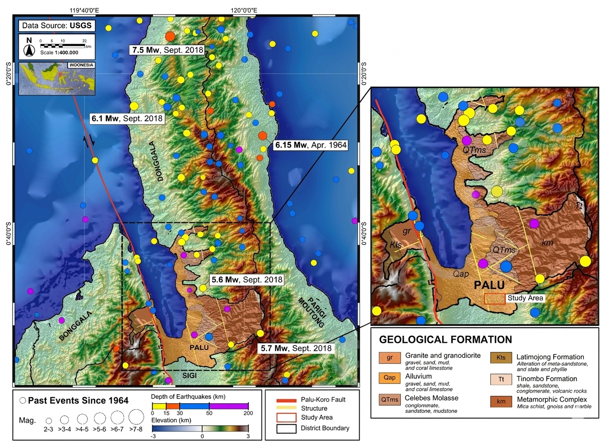

MAKASSAR, Indonesia May 22 2026 /GLOHAMOD/– Nearly eight years after the devastating 2018 Palu earthquake and liquefaction disaster, the ground beneath Petobo is still telling its story. Once one of the hardest-hit areas during the Mw 7.5 earthquake, Petobo became a symbol of how powerful seismic forces can instantly reshape communities. Now, new scientific findings reveal that the land is slowly recovering—and its hidden changes may help protect lives in the future.
A recent study titled Temporal Evolution of Site Response in Petobo’s Post-Liquefaction Zone, Palu, Indonesia: A Comparative HVSR Curve Analysis, published in Soil Dynamics and Earthquake Engineering by Elsevier in April 2026, provides groundbreaking insight into how soil conditions beneath Petobo have changed over time since the disaster.
Using the Horizontal-to-Vertical Spectral Ratio (HVSR) method combined with shear-wave velocity profiling, scientists monitored underground changes at several locations before the 2018 earthquake, shortly after the disaster in 2019, and again three years later in 2021.
Their findings reveal that the subsurface beneath Petobo remains dynamic. In some downstream areas, layers of soft sediment became thicker due to material deposition, causing lower ground stiffness and reduced dominant frequencies. Meanwhile, upstream and central areas experienced stronger soil compaction, erosion, and pressure-related changes immediately after the earthquake.
Perhaps most remarkably, areas outside the visibly damaged liquefaction corridor also showed temporary weakening right after the earthquake, followed by gradual recovery over the next three years.
This proves that earthquake damage is not always visible from the surface. Deep underground, soil properties can shift dramatically long after a major seismic event.
The study confirms that advanced but cost-effective monitoring methods can track these hidden changes accurately. By comparing wave patterns with standard geotechnical data, researchers demonstrated that HVSR technology offers a reliable, non-invasive way to monitor soil recovery in earthquake-prone regions.
These findings strongly support SDG 3: Good Health and Well-being, as better understanding of post-earthquake soil recovery directly improves public safety and reduces future disaster risks. Communities rebuilt on unstable land remain vulnerable unless underground conditions are properly reassessed.
The research also contributes to SDG 4: Quality Education by transforming complex geophysical monitoring into practical scientific knowledge that strengthens disaster awareness and preparedness among local governments and communities.
Equally important, the study advances SDG 17: Partnerships for the Goals, highlighting how collaboration between researchers, engineers, policymakers, and local authorities is essential for building safer reconstruction strategies after disasters.
For Petobo, this research is more than a scientific milestone. It is evidence that resilience can be measured, monitored, and strengthened through knowledge.
By listening carefully to the earth’s subtle vibrations, scientists are helping communities rebuild not just on stronger ground—but on stronger understanding for generations to come.
Reference:
DOI: https://doi.org/10.1016/j.soildyn.2026.110117
Article Title: Temporal Evolution of Site Response in Petobo’s Post-Liquefaction Zone, Palu, Indonesia: A Comparative HVSR Curve Analysis
Journal: Soil Dynamics and Earthquake Engineering
Publisher: Elsevier
Publication Date: April 2026
Contact:
Saaduddin, M. Sc., PhD
+62 8992890320
Saad@sci.unhas.ac.id