

SUMMARY
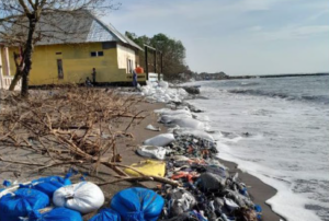
MAKASSAR, Indonesia, September 17, 2026/CSR/ – Tidal flooding, or coastal flooding caused by high tides, is becoming an increasingly frequent threat in coastal areas, particularly in low-lying regions, with wide-ranging impacts. This phenomenon, driven by extreme tidal conditions, sea-level rise, and land subsidence, disrupts socio-economic activities, damages infrastructure, and threatens the sustainability of coastal settlements. Climate change, including rising ocean temperatures and polar ice loss, further exacerbates these risks, making coastal areas, including Indonesia, highly vulnerable. In addition, coastal erosion and ecosystem degradation further increase vulnerability.
Therefore, the development of a multifunctional ecological and social corridor may provide an innovative approach to addressing these challenges. This concept integrates environmental protection with the provision of social spaces, such as parks, pedestrian pathways, and recreational facilities, to reduce disaster risks while improving community quality of life. The approach supports the achievement of the Sustainable Development Goals (SDGs), particularly SDG 11 (Sustainable Cities and Communities) and SDG 13 (Climate Action), by strengthening the resilience of coastal areas to climate change and natural hazards.
The challenges faced by coastal areas differ between urban areas such as Makassar and rural areas such as Minasamaupata. Makassar, which is experiencing rapid urbanization and increasing population density, is vulnerable to tidal flooding and coastal erosion, while Minasamaupata, where communities depend heavily on fisheries, faces threats to socio-economic resilience due to ecosystem degradation. Developing multifunctional ecological and social corridors in both areas could strengthen climate resilience through mangrove rehabilitation and the provision of social infrastructure adapted to local needs. Collaboration among government institutions, local communities, and the private sector is essential for creating more resilient and sustainable coastal settlements.
Long-Term Objectives
In the long term, the development of a coastal corridor based on multifunctional vegetation and recreational embankments is expected to provide multiple benefits for environmental resilience and community well-being. Through the planting and restoration of appropriate coastal vegetation, the area will become more resilient to sea-level rise and coastal erosion, thereby strengthening the climate resilience of coastal environments.
The corridor will also function as an embankment that not only protects inland areas from tidal flooding but also provides public spaces for activities such as jogging, cycling, and recreation. The social corridor within the area may support local economic development based on ecotourism and sustainable fisheries, creating new livelihood opportunities for local communities.
The availability of green public spaces and social infrastructure is also expected to improve residents' quality of life, reduce health risks associated with tidal flooding, and create a safer and more comfortable living environment. The success of this strategy will depend strongly on multistakeholder collaboration involving government institutions, local communities, academics, and the private sector to establish an inclusive and sustainable model of coastal governance.
In addition to providing social and economic benefits, the corridor will contribute to maintaining coastal ecosystem balance, protecting biodiversity, and strengthening the adaptive capacity of ecosystems to climate change. Through an integrated approach, this strategy is expected to provide a sustainable long-term solution to environmental and social challenges in coastal areas.
Specific Targets
The following specific targets are proposed through the development of a multifunctional vegetation-based coastal corridor and recreational embankment in North Galesong:
1. Climate and Environmental Resilience
- Reduction of coastal erosion by X% within Y years through the planting of coastal vegetation that is resilient to marine waves.
- Reduction of tidal flooding impacts by increasing the capacity of multifunctional embankments to withstand high-tide water levels.
- Expansion of coastal vegetation coverage by X hectares to strengthen shoreline protection and enhance biodiversity.
2. Sustainable Economic Empowerment
- Increase in coastal community income by X% through ecotourism and sustainable fisheries supported by the social corridor.
- Creation of X new employment opportunities in ecotourism, fisheries, and related supporting services.
- Development of local micro, small, and medium enterprises (MSMEs) based on coastal products and nature-based tourism to improve community livelihoods.
Methods
The research methods will employ several approaches to investigate biomimicry-based solutions for managing tidal flooding in North Galesong:
1. Geographic Information System (GIS)
GIS will be used to map geographical conditions, topography, and shoreline changes to understand the spatial patterns and impacts of coastal erosion and tidal flooding.
2. Analytical Hierarchy Process (AHP)
AHP will be used to determine the priority of mitigation strategies based on environmental, economic, and social factors.
3. Surveys and Interviews
Surveys and interviews will be conducted to collect socio-economic data, assess community perceptions, and identify local needs and potentials for implementing coastal adaptation strategies.
These methods will be applied in an integrated manner to develop effective and sustainable biomimicry-based solutions for addressing tidal flooding and strengthening coastal resilience.
Alignment with the UNHAS Strategic Plan
The development of a multifunctional vegetation-based coastal corridor and recreational embankment in North Galesong is aligned with the Strategic Plan (Renstra) of Hasanuddin University (UNHAS) 2020–2024 in several respects:
1. Development of Science and Technology Based on the Indonesian Maritime Continent (BMI)
UNHAS is committed to becoming a center of excellence for the development of science and technology focusing on the Indonesian Maritime Continent (Benua Maritim Indonesia/BMI). This project supports this commitment by investigating biomimicry-based solutions for tidal-flood mitigation, which are highly relevant to environmental challenges in maritime regions.
2. Multistakeholder Collaboration
The UNHAS Strategic Plan emphasizes collaboration among government institutions, academia, communities, and the private sector. The proposed coastal corridor initiative involves multiple stakeholders and seeks to establish an inclusive and sustainable model of coastal governance.
3. Community Empowerment and Community Engagement
UNHAS places emphasis on community engagement through the downstream application of research and the delivery of research-based benefits to society. This project has the potential to improve the well-being of coastal communities through ecotourism and sustainable fisheries, in line with the university's commitment to community empowerment.
Accordingly, the project not only supports UNHAS's vision of becoming a center of excellence in science and technology development based on the Indonesian Maritime Continent but also strengthens the university's role in community engagement and multistakeholder collaboration.
By recognizing the importance of integrating environmental management with socio-economic planning, this research aims to explore multifunctional solutions for strengthening the resilience of coastal settlements to climate change while improving the quality of life of coastal communities.
Keywords: Tidal flooding; Climate change; Multifunctional ecological and social corridor; Coastal resilience; Sustainable Development Goals (SDGs)
Contact
Idawarni Asmal
081357922950
idawarniasmal@yahoo.com
idawarni@unhas.ac.id
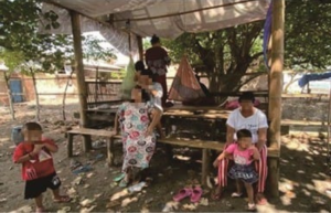
MAKASSAR, Indonesia April 7 2026/CSR/ – In many coastal settlements, survival is not just about individual strength—it is about togetherness. While modern urban living often emphasizes privacy and independence, coastal communities in Indonesia remind us of a different value: the importance of shared spaces in building strong, resilient societies.
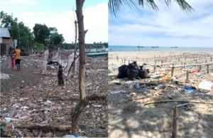
MAKASSAR, Indonesia April 7 2026/CSR/ – What if the solution to our growing waste problem has been with us all along? In many coastal communities, especially in Indonesia, traditional knowledge—often called local wisdom—is proving to be a powerful tool in managing waste more sustainably.
MAKASSAR, Indonesia April 7 2026/CSR/ – The coastline is more than just a meeting point between land and sea—it is a lifeline for communities. In North Galesong, Indonesia, this lifeline is under serious threat. Once a stable and productive coastal area, it is now facing rapid degradation. But what is causing this damage? The answer lies closer to us than we might think: human activity.